 1200 Hrs 8th - high pressure to the east that gave the month's warmest day
Very dry and sunny - temperature close to average.
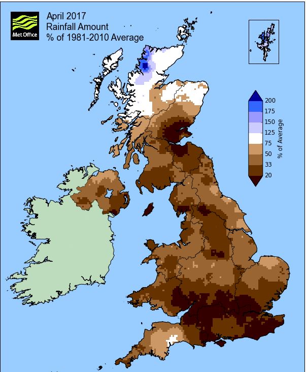
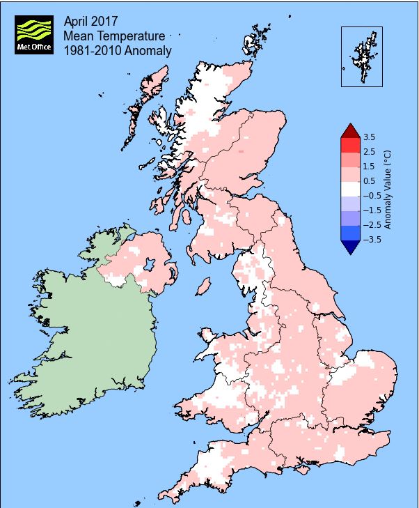
April confirmed itself as the driest month of the year with rainfall just under one third of average and after a cool end to the month, the mean temperature fell back to near normal. For the majority of the month night-time minima kept the temperature above average, with the day-time maximums at or just below average and indeed many of the days felt quite fresh with winds from the W-NW. That cool end to the month saw a little snow and hail 24-25th with some frosts, but otherwise it was a quiet month.
Winds were anomalously from the NW and it was often breezy, giving that slightly fresher feel, although this was generally off-set by the brighter conditions and lack of any meaningful rainfall. Only two days attained 15°c, none after the 8th, with temperatures typically stuck in the range of 11-13°c.
A dry first half of the month then saw the first wet day arrive on the 16th after which rainfall was patchy and showery, very much continuing the dry start to the year.
MSLP of 1021.0 Mb was +7.3 Mb above the local average for April, but apart from the 7-9th when high pressure sat over the UK, it was more a case of it lying in close proximity to the UK, in particular just off the west coast of Eire and therefore never truly established.
Overall a mean minimum of 3.56°c and a mean maximum of 11.86°c saw the temperature 0.3°c above the 1981-2010 average and it was the warmest since 2014. The highest maximum temperature recorded was 16.4°c (8th), the lowest minimum -3.4°c (25th).
Rainfall of 19.6 mm (Crosby Ravensworth School 19.4 mm - Castlehowe Scar 22.1 mm) made it the driest April since 2010 (the 2nd driest of the 10 recorded) and was 32.2% of average for 2008-16. One of those rare months when Maulds Meaburn is wetter that Crosby Ravensworth, but solely due to the winds being predominantly from the north.
Locally, rainfall percentages were also well below average and typically one third or less than normal. They ranged from a low of just 17.3% at Brothers Water to 53.3% at Haresceugh Castle and at Seathwaite Farm it was the driest since 1980 (4th driest since 1961).
At the Met' Office site at Newton Rigg, 22.0 mm (42.1%) made it the driest since 2007 and in a series back to 1900 there has been 18 drier and 99 wetter. In a series back to 1952 a mean temperature of 7.55°c is the warmest since 2014 with 42 having been colder, 19 warmer and 3 having the same mean temperature (1 yr of missing data).
Figures from the Environment Agency’s rainfall sites were, (figure in brackets being the monthly average for 1961-90) ‘Data kindly provided by the Hydrometry and Telemetry team of the Environment Agency (Penrith)’:
Kirkby Thore 18.6 mm (55.4 mm)
Haresceugh Castle (Kirkoswald) 28.25 mm (53.0 mm)
Brothers Water 22.26 mm (129 mm) and
49.2 mm at Seathwaite Farm (Borrowdale - 180 mm [average for 1981-2010])
1st - 4th It was a mixed picture at the start of the month with high pressure (HP), 2nd-3rd, sandwiched inbetween Low Pressure (LP) on the 1st and 4th.
The LP of the 1st was moving north away from the UK, but the associated troughs and a weak upper occlusion gave the only rain (1.6 mm) of the entire period and indeed until the 12th. HP off the northern tip of Spain then ridged strongly north over the UK and which resulted in some sunny spells. The temperature upto the 3rd was stuck just over 13°c and in a strong breeze on the 3rd it felt quite fresh.
A frontal system from off the Atlantic arrived late on the 3rd to give some drizzle (0.1 mm), the 4th then becoming a transitional day as HP would once again build behind those fronts as they cleared east.
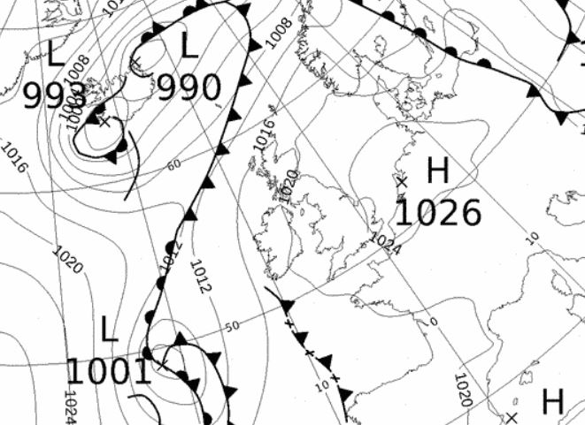
5th - 8th HP would than build from the SW and become dominant over the UK, but there was a lot of cloud trapped within the system and it was only later in the period that we got to see some sun as the HP drifted over to the North Sea, however, it remained dry.
Temperatures were not especially high, the 5th dipped to 10.5°c, with a steady recovery in the days that followed. The 8th was by far the best day of the period, which saw cloudless, sunny skies and which after starting with a frost of -1.5°c, became pleasantly warm at 16.4°c (61.5°f) and which would be the month's warmest day.
1200 Hrs 8th - high pressure to the east that gave the month's warmest day
9th - 13th A cold front that was strung out between LP west of Spain and another system north of Iceland, move SE across the UK on the 9th and whilst not bringing any rain, it did bring fresher conditions in the run up to and throughout the Easter Bank Holiday.
Behind that cold front HP tried to re-establish itself, but never succeeded, tending to remain further south and allowing fronts to pass close to the north of the UK on a brisk W'ly flow, but which only gave us the odd shower or spot of rain.
The first rain (1.5 mm) since the start of the month came in the early hours of the 12th as another cold front swept SE over the UK, but with the HP again trying, but failing, to build behind it.
Temperatures during the 11-13th dipped and typically struggled just above 10°c and indeed the 13th only just reached that mark.
14th - 17th Easter Bank Holiday remained cool and fresh with a mix of days that at least offered something to be able to get outside.
A pair of cold fronts moved across the UK on the 14th (Good Friday) giving a cloudy day with the odd shower, but a cool and fresh NW'ly flow was introduced behind those fronts as they cleared east.
The Saturday was the best day of Easter, cool and breezy, but with sunny spells developing in the afternoon, although a maximum of 10.3°c did feel a little fresh. Easter Sunday was the poorest day of the weekend, with rain from overnight continuing for most of the morning. Even after the rain it never brightened, remaining cold under overcast skies with further showers and then more rain at tea-time. Whilst 5.8 mm is not a lot of rain, it was enough to become the month's wettest day.
With the fronts of the 16th clearing away, the 17th was a better day, gradually brightening to give some sunny intervals, but now with a N'ly flow it remained on the cool side.
18th - 23rd Once again HP would try to become established over the UK and whilst it was the more dominant feature, the occasional front would still pass over the UK - and in a W'ly flow, day-time temperatures remained depressed and typically just below the seasonal average.
The HP had two centres, one in the North Sea and the second to the SW of Eire. Those fronts that did travel W-E over the UK gave no rain of any note and the days were generally quiet. During the period, clear skies overnight into the 18th gave a sharp frost of -3.1°c which was followed by a decent day and then the 21st at 13.5°c was the warmest day since the 9th, with the temperatures never recovering that far until the very end of the month.
24th - 27th Whilst the month had been running warmer than average upto this point (due to the milder than average nights), it would now fall below average as we entered a much colder phase with temperatures down into single figures.
The virtually ever present HP was still in the Atlantic, sat slightly further south, whilst a small depression would build to the west of Scotland, stay north of the UK and travel over to Norway - this resulted in a much colder N'ly flow and introduced an Arctic Maritime air mass and with it, frosts and some wintry showers.
A cold front associated to that LP swept SE across the UK during the 24th and this heralded the introduction of that cold air. That front had a little rain on it as it passed through, it was then brighter behind that front until increasing cloud in the afternoon brought a number of showers. Those showers were wintry in nature, some of hail, some of snow and then in the early evening we had an hour of snow.
Under clearer skies the temperature dipped quickly overnight into the 25th and -3.4°c (25.9°f) would be the month's lowest minimum. By now the NW'ly wind was persistent and cold and whilst the 24th had dropped below 10°c, the 25th would fall further, 7.9°c (46.2°f) and easily the month's coldest day.
The 25th saw further hail showers in the afternoon, mixed with sunny intervals as it remained quite cold and there is something quite British about cutting your grass whilst it is snowing! The 26th also started with a frost, with a sunny morning being replaced with a cloudier afternoon, still cold (8.2°c), but without any showers.
This colder phase would end come the 27th, the HP being squeezed out by a frontal system moving N-S later during the day and which brought a spell of rain (5.0 mm) from 1830 hrs.
28th - 30th A LP system would build close to the SW of the UK, pivot and introduce winds from the SE and with it a slight rise in temperatures, upto 14.7°c on the 30th.
The LP would remain to our south and whilst the amount of cloud increased, the rain bearing fronts never bothered us and the month finished dry.
Rainfall totalled 19.6 mm for the month, with rain recorded on 12 days of which 6 were 'Wet days' (1.0mm +).
The Mean Temperature for the month was 7.71°c -- The Mean Max' was 11.86°c -- The Mean Min' 3.56°c.
We had 5 Air Frosts in the month (year 30) -- Grass frosts totalled 11 (year 59).
The 1 foot soil temp ranged from a low of 8.3°c on the 27-28th to a high of 9.8°c on the 22nd and 24th -- with a monthly mean of 9.2°c
The 1 meter soil temp ranged from a low of 7.7°c on the 1st to a high of 8.9°c on the 24-26th -- with a monthly mean of 8.5°c
COMPARISONS:-
* April 2017 rainfall was 32.2% of the average for 2008 - 2016
* April 2017 was 0.07°c colder than the average for 2009 - 2016 and 0.3°c warmer than the local long term average 1981-2010
* This makes the Jan' to April period of 2017 1.07°c warmer than the average for 2009-16 and with 67.6% of average rainfall for 2008-16
JANUARY 2010
FEBRUARY 2010
MARCH 2010
APRIL 2010
MAY 2010
JUNE 2010
JULY 2010
AUGUST 2010
SEPTEMBER 2010
OCTOBER 2010
NOVEMBER 2010
DECEMBER 2010
JANUARY 2011
FEBRUARY 2011
MARCH 2011
APRIL 2011
MAY 2011
JUNE 2011
JULY 2011
AUGUST 2011
SEPTEMBER 2011
OCTOBER 2011
NOVEMBER 2011
DECEMBER 2011
JANUARY 2012
FEBRUARY 2012
MARCH 2012
APRIL 2012
MAY 2012
JUNE 2012
JULY 2012
AUGUST 2012
SEPTEMBER 2012
OCTOBER 2012
NOVEMBER 2012
DECEMBER 2012
SUMMER 2012
REVIEW OF 2012
JANUARY 2013
FEBRUARY 2013
MARCH 2013
APRIL 2013
MAY 2013
JUNE 2013
JULY 2013
AUGUST 2013
SEPTEMBER 2013
OCTOBER 2013
NOVEMBER 2013
DECEMBER 2013
REVIEW OF 2013
JANUARY 2014
FEBRUARY 2014
MARCH 2014
APRIL 2014
MAY 2014
JUNE 2014
JULY 2014
AUGUST 2014
SEPTEMBER 2014
OCTOBER 2014
NOVEMBER 2014
DECEMBER 2014
WINTER 2014
REVIEW OF 2014
JANUARY 2015
FEBRUARY 2015
MARCH 2015
APRIL 2015
MAY 2015
JUNE 2015
JULY 2015
AUGUST 2015
SEPTEMBER 2015
OCTOBER 2015
NOVEMBER 2015
DECEMBER 2015
REVIEW OF 2015
JANUARY 2016
FEBRUARY 2016
MARCH 2016
APRIL 2016
MAY 2016
JUNE 2016
JULY 2016
AUGUST 2016
SEPTEMBER 2016
OCTOBER 2016
NOVEMBER 2016
DECEMBER 2016
REVIEW OF 2016
JANUARY 2017
FEBRUARY 2017
MARCH 2017
OTHER ARTICLES
The Oldest Inhabitant
An Inch Of Scotch Mist
© Darren Rogers 2010-17
Want to comment on this site? email